


Ruby Crest Trail 2020 - An Alpine Island Rising from the Desert Floor
Ruby Crest Trail
Elevation: Wines Peak - 10,920’ (Ruby Crest Trail High Point)
Route: Harrison Pass to Lamoille Canyon
Nights on Trail: 3
Miles: ~40
Shuttle: Self
Trailhead: Harrison Pass (just north)
Agency: Humboldt-Toiyabe National Forest
Dates Hiked: 09/08/2020 to 09/13/2020
For those interested, here is a list of my gear that I have found works well for me. This is, of course, an affiliate link and your enjoyment of these may vary:
09/08/2020
It started off by looking at a map. Probably about 5 years ago, I came across a dark skies map that showed the darkest areas of the country. I scanned around, looking at different places and came across a mountain range in northeastern Nevada.
The Ruby Mountains, the map read. I had never heard of them. I started doing some research and found out they aren’t visited by that many people. An island of alpine ridges rising from the desert, it offered a place to go backpacking.
I discovered there was a through-hike that followed the northern two-thirds of the crest, starting from Harrison Pass and ending in Lamoille Canyon, depending on which way you go. It was ~33 miles, depending on where you camped, and had a middle section almost completely above the tree line with no water in an 11-mile stretch.
There were no bears, and there were no permits required. There shouldn’t be many people for most of the trail.
I recently found an entry in one of my journals from March 2015. In between notes about opening a restaurant, I had made a call to the Ruby Mountain Ranger District, asking about weather. The note reads:
“Open April 29th. Could be snow, campsites open Monday”
I put the Ruby Mountains on my list. I made tentative plans for years, but other trips always came ahead of it. I chatted about it with Jason and Jeff on my Wonderland Trail trip last year. At the airport in Seattle, just before we were about to hop on different planes on our way home, Jason and I drank some coffee, read about the trail on our phones, and agreed to visit the Ruby Mountains in 2020.

Notes from March 2015
Day 0: San Diego to Thomas Canyon Campground - 11.5 hours of driving
The PD, Jason, and I headed out for a long drive from San Diego to the Ruby Mountains, Jeff was going to meet us there from Bend.
We charted a course through Death Valley, for some photo opportunities. However, the wind was howling and blowing the smoke from the fires in the Sierra Nevada and the sand from the desert around us. Visibility was limited for hours.

The Six-Pack of Peaks Disco and The PD's Rooftop Tent at Thomas Canyon Campground
After about 12 hours of driving, we met at Thomas Canyon Campground in the Ruby Mountains at nearly the same time. The sun was going down and we were all a little road-weary.
I reserved a double-sized campground, since there were going to be four of us. There were two large picnic tables; plenty of room for us to be socially distant. The PD and I were going to sleep in his new-ish rooftop tent and Jeff and Jason set up their backpacking tents in the ample tent area.

Jeff and Jason's Tents at Thomas Canyon Campground
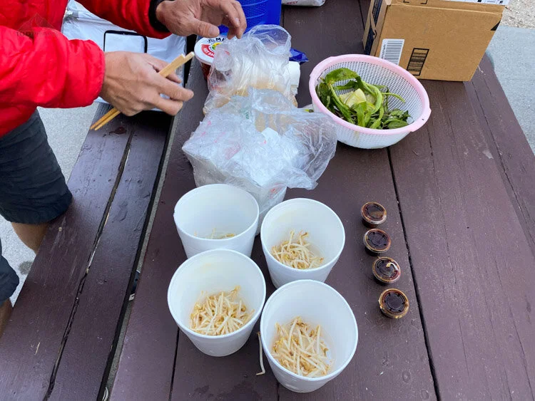
As the temperature rapidly dropped toward freezing, we bundled up and heated up dinner, which was authentic phở. It really hit the spot as Jeff shared some beer he brought with all of us.


Jason mentioned that one of his friends might be joining us somewhere on the trail, since, due to the many fires in California, the forests were all closing down. For now, our skies were clear and crisp, once we got into Eastern Nevada, although it was clearly hazy for most of the drive.
We settled in for a chilly and windy night.
It was interesting to navigate down the ladder of the rooftop tent in the middle of the gusty night, aspens whooshing all around, for a bio break in the icy moonlight.
Day 1: Harrison Pass to South Fork Smith Creek - ~8.5 Miles - ~1,800’/1,900’ up/down
We woke up to a frigid morning and I hadn’t slept well. In fact, for a variety of reasons, I hadn’t slept well in about three days. There was ice on top of Lamoille Creek. We had a quick breakfast of Cotija's breakfast burritos and packed up our backpacks for the trail. I was a little chilly, but knew I would warm up once we got started.
We were going to drop off the PD’s car at the northern end trailhead in Lamoille Canyon and take Jeff’s Disco over to the starting trailhead at Harrison Pass.
We drove into Lamoille Canyon, and it’s easy to see why this part of the Ruby Mountains is so heavily visited. Glacial valleys are numerous here and Lamoille Canyon is the biggest. It’s hard to believe this granite beauty of a mountain range rises so abruptly out of the sage-covered desert floor.

Beautiful Lamoille Canyon on the way to our exit trailhead
We dropped off the PD’s car, making sure we didn’t leave anything behind. The PD brought some dry ice, so I left some beer chilling for us at the end of the trip. We then piled into Jeff’s Disco, masks aplenty, and headed around the west side of the range to get to our southern trailhead at Harrison Pass.
All reports indicated that the forest road north of Harrison Pass was simple and that most people with 4WD and high clearance should be able to make it to the kiosk without a problem. Some people, however, park at the pass itself, adding 2-3 miles and ~800’ of early gain to the trip.
Since Jeff’s Disco was an off-road machine, we headed left, passing the wide turnouts at the top of the nicely graded dirt road and drove up Forest Road 353 (Ruby Crest Trail).
The first part was easy. We cruised along, excited for the journey to truly begin. We passed a cattle gate and I got out to open it for the car and was instantly chilled by the strong cold winds. I closed the gate as Jeff nudged the Disco forward, I hurried back into the car, shivering.
We continued driving slowly up and down some pretty steep sections and had to pause at one section where there was a sizable rock in the road. While we had a car with high clearance, none of us were truly experienced off-roaders. We mentally tried each line and decided on heading up the right. The left tires bounced right over the rock and we were up and over. As we pulled into the turnout by the kiosk, a pebble was left in my mind as to how we would approach that on the way down.

Our group at the Harrison Pass Trailhead
Once again, when I got out of the car, I was instantly chilled by the gusting winds. In hindsight, I should have put on my rain shell, as a layer of wind protection, but I was confident I would warm up once I got started.
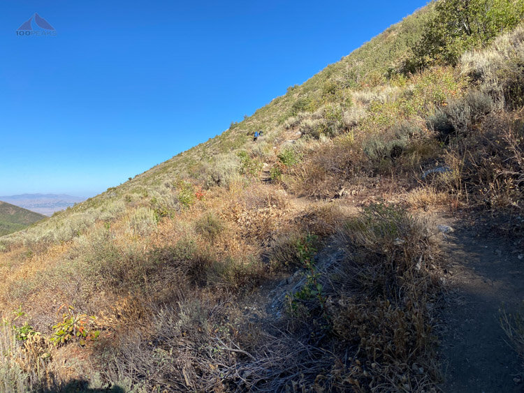
We headed up the wide trail, pretty sure the car could have made it at least a little further up the way. We chatted and looked around at our new environment, an old dirt road rolling through low bushes on the side of Green Mountain. The fresh air was great and it was nice to be outside.

Getting started on the trail, heading up and up
The trail went in and out of aspen groves as it finally narrowed enough for the car to not have made it.
The trail continued to round the mountain, topping over a shoulder what I called the Gilbert Creek Saddle. We stopped for a snack and were happy to be making great time. In my head, that was the climb of the day. I hadn’t researched this route closely since before my Sierra trip with my daughter the month before, and I was a little hazy on some of the details.

The trail gets greener as we approach Green Mountain


I was wrong, there was to be plenty of climbing ahead, I just didn’t know it yet.
We ascended and descended, as we entered different drainages. We stopped for a rest near McCutcheon Creek and I rested my head on my backpack and nearly went to sleep. I was in the sun, but would get chilled whenever the breeze blew, which was often.
Here it was, that feeling again. That mood that permeated my last few trips. It first appeared on my solo trip to Mount Langley, and it appeared again on my trip to the Sierra to attempt Mount Whitney last month.
I wasn’t enjoying myself. I didn’t want to be there. I started doubting whether or not I even wanted to backpack ever again. I knew this feeling wasn’t real, but it was there nonetheless.
Looking back, I can chalk it up to a variety of factors:
Three nights with little sleep
The effect of elevation (we were around 9,000’)
I was cold and uncomfortable
I was possibly dehydrated with low calories
As I checked the map, I realized there were a couple of decent climbs ahead of us that I had forgotten
I wasn’t feeling strong.
Months of dealing with non-stop COVID changes while running a restaurant
Another possibility was that there was a reaction within me that I simply get frustrated when the weather isn’t ideal. I have these expectations of how a trip will go and when it’s not perfect, my mood sinks. In the past decade, I’ve had many trips altered by the weather.
I’ve had to turn around within a stone’s throw of Mount Langley and both my Mount Whitney trip in 2020, and my first attempt at Mount Whitney in 2021. I’ve had to bail completely in Kootenay National Park and my Chicken Spring Lake trip. I was damp for a week on my Wonderland Trail Trip.
And let’s not forget the mother of them all, my backpacking trip to Mount Whitney in 1984, when it rained 8 out of 9 days, including a crazy hailstorm coming down Mount Whitney.
It’s probably all of the above. I would muse on this for the rest of the day. I wanted to crack this nut so I could enjoy these adventures as much as I’d used to.
We climbed around a ridge and began our climb up to what I dubbed Smith Creek Pass. The trail edged around a bowl and then went what looked impossibly straight up to the pass.

Heading steeply up to Smith Creek Pass on the left
We got our rhythm and headed up. It wasn’t as steep once we got close. Once at the pass, we were presented with incredible views. I chatted about my mood with the group, trying to shake it off and feeling it drop away. As always, they were true friends and very supportive.


I ate and drank as much I could and felt better. The rest of the day was downhill. We’d drop about 1,500’ in ~1.75 miles.
We reached South Fork Smith Creek and had the entire place to ourselves. There were campsites in several areas and we chose a large one up above the creek, within the aspen grove. There were logs to sit on and plenty of flat spots for a tent. It was likely a camp for horse riders. There was decades-old graffiti carved into the trees, by shepherds from days gone by.

Our large campsite at South Fork Smith Creek

Our tent at South Fork Smith Creek
We settled in and had dinner, telling stories and shaking off the cold wind until it was time to head into our tents for an early evening. I took two each of ibuprofen and benadryl and slept like a baby.
The wind gusted again overnight sounding like a freight train, but we were protected somewhat by our campsite below the ridgeline and in the trees.

The crossing at South Fork Smith Creek
Day 2: South Fork Smith Creek to Overland Lake - ~6 Miles - 2,364’/839’ gain/loss
I woke up feeling better. I had slept really well, catching up on sleep. It was still pretty chilly, but it was definitely warmer than the day before. We made our breakfasts, gathered our things and prepared ourselves for a relatively short day with a lot of climbing.
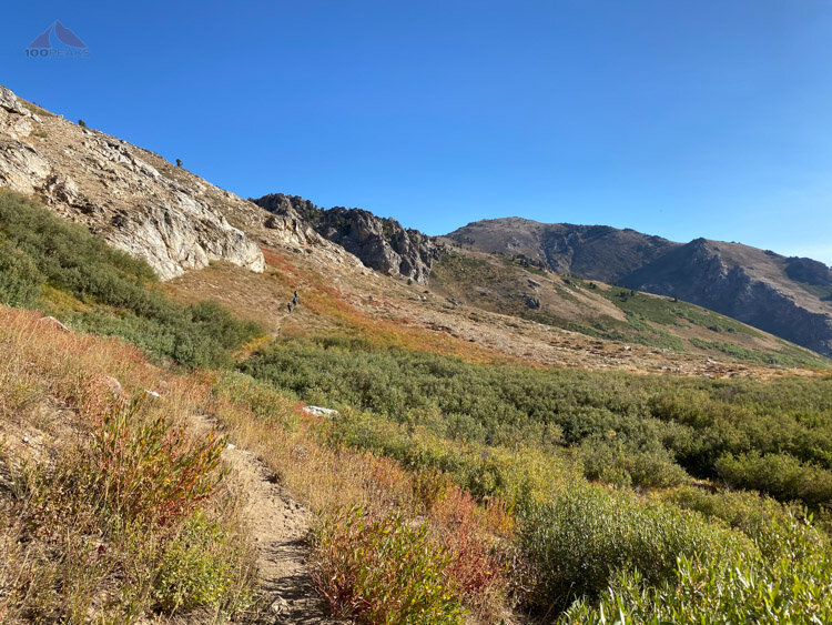
We crossed the creek and headed uphill toward the ridge that divided the South and Middle Forks of Smith Creek. We got an excellent view of the South Fork Smith Creek drainage. These were all beautiful U-shaped glacial valleys.
Climbing up and over, first thing in the morning, to Middle and North Forks of Smith Creek

Looking up the scenic South Fork Smith Creek glacial valley
We dropped down into a thick aspen grove, crossing Middle Fork Smith Creek and hiked up the other side. I was feeling good and we had a nice pace. I was enjoying the views all around as we took a break on the top of a ridge. We could see all the way to the desert floor. Below us, a shepherd or cowboy had a large tarp tent on a flat section of the ridge.


It was a nice spot and my mood was great. I felt like I had completely shaken whatever was bugging me the day before. We looked up the drainage to another pass at the top of a bowl. We had some climbing to do that looked pretty steep. However, the day was beautiful and the scenery was great.
I stopped often to take pictures. The area wasn’t as jaw-dropping as the Sierra Nevada, but it was simply a different flavor of beauty.
We descended into the North Fork Smith Creek Drainage and started the upward journey to the pass. It wasn’t too steep until we hit the headwall of the valley and the trail started switching back and forth. We could see some cows and a horse in a green patch, likely near a spring. We could just make out a person down there with the herd.

Hiking to the top of the canyon - the pass is upper middle left


Once we got to the top of the pass, we realized that we still had a little bit more climbing to do, so we rewarded ourselves with a nice break in the sun.
Once again, it’s these little moments of shared time that makes these trips so special. We always relax, joke around and trade stories, absorbing the current experience. These journeys wouldn’t be as special if I was alone. Or at least a different kind of special.
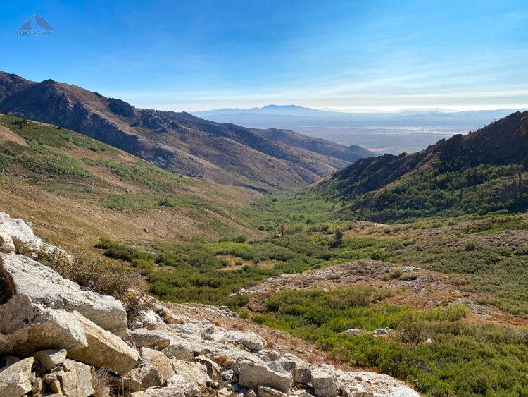
The PD relaxed on a log, as we snacked and looked out to the desert floor, about 4,000’ below us. Just a small little climb and we’d drop down to our campsite for the day.

After what we thought was the top, we had a little more to go
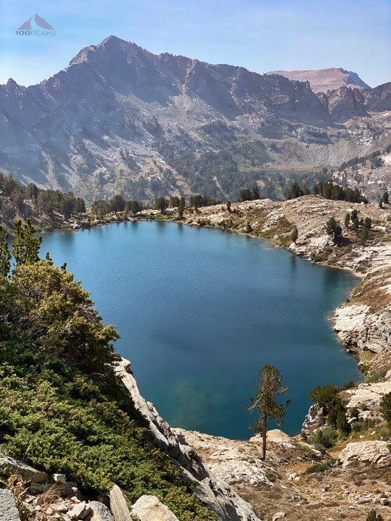
We climbed a steep last climb and topped the ridge. Within a few feet, we went from a low brush environment, to an alpine bowl with two lakes in it. It felt like a little slice of the Sierra Nevada in the Ruby Mountains.

Looking down at Overland Lake and the tarn above it - we'd camp on the far side of the lake on the rock outcrop at 10:00

Getting close to our camp for the night at Overland Lake
Excited to be done for the day and to check out Overland lake, we switched-back quickly down and found ourselves at the edge of the lake. There were plenty of spots near the old cabin at the edge of the lake, but Jeff scouted around and found an amazing spot near a large granite outcrop that jutted into the lake.
It would be one of my favorite days of camping of all time.

Overland Lake was a wonderful blue with a hunters cabin on the far shore
We picked up our packs by the cabin and carried them across a small creek and into the trees. There was evidence of past campfires (off-limits during our time in the Ruby Mountains) and horses (there were plenty of droppings in every campsite), but we found some nice flat spots for our tents in the trees.

Relaxing in the sun at Overland Lake
We got into the lake for a swim. The sun was nice, but only when the air was still. It was a pretty cool day, so the lake was very cold. We all made it in and, as usual, were instantly refreshed. All smiles, we climbed out and dried out in the sun. I put my wet clothes on a rock and spread out my foam mat, basking in the warmth of the rays. We lounged on the large slab for what seemed like most of the day.

Our tents at Overland Lake
We arrived at the campsite early enough to enjoy it, and enjoy it we did.
The feeling of calm permeated all of us as we took turns dozing in the sun. We heard some gunshots in the near distance and another group appeared, grouse in hand. The trout were plentiful in the lake the group fished on the opposite shore and caught fish after fish.
I lay on the edge of the slab, looking down at the trout, swimming like little sharks in the emerald water. It was wonderful. The breeze would blow from time to time, cooling us off, but nothing lasting.

Jason taking pictures at Overland Lake
Overland Lake Panorama
The day slowly moved forward as we filtered water and had dinner. I realized I was ravenous. As darkness fell, I was considering heading off to an early bedtime when Jason and Jeff reminded me that the dark sky was why we all were even there in the first place.

Our home for the night
They were right. I was tired, but I really wanted to see the sky.
We put on our warmer clothes and I lounged on my foam pad, staring up at the darkening sky.

Jason's astrophotography

iPhone Milky Way
The milky way glowed above us as meteors streaked across the sky. Satellites moved along their smooth orbits. It was amazing. We lingered out there for hours, often in silence, as we stayed up later than we normally do. Jason’s camera occasionally clicked as he set up his tripod for capturing the glowing galaxy we live in.
At around 10PM, Jason and I were last to our respective tents.
Day 3: Overland Lake to North Furlong Spring - ~12.7 Miles - ~3,000’/2,644’ gain/loss
Morning alpenglow at Overland Lake
Once again, I slept incredibly well. We woke up early, as we had a long day ahead of us. The PD and I repeated a mistake we made years ago when we brought some Huevos Rancheros that requires a skillet. It wasn’t until we added hot water and waited that we realized our error. It was a seasoned soup that was inedible. We won’t be making that mistake again.
We had plenty of other food, however, so we ate our alternative breakfast, packed up, and got going.
A pleasant morning hike - the start of the rolling ridge in the center rear
We headed out through the campsite back to the trail, which offered us views to the east before headed steeply downward toward the Overland Creek drainage. There were a couple of last opportunities for water.
Water sources between Overland Lake and North Furlong
There was one place that everyone mentioned, a cascade only about 1.25 miles from Overland Lake, which I’ll unofficially dub the Middle Fork of Overland Creek. Every source I researched mentioned that this is the only reliable source of water past Overland Lake.However, we saw two more creeks further along, right next to each other, about 1.8 miles from Overland Lake, which I’ll unofficially dub the North Fork of Overland Creek. This trip took place in mid-September, so this might be available for some, but I probably wouldn’t take the chance, based on my limited knowledge. One might as well just load up near Overland Lake and carry it for the day. However, if you’re traveling south and have run out of water on top of the ridge, you may be able to get some relief a little sooner than Overland Lake.
The first part of this hike skirts the Overland Creek drainage and rises slowly up to the 10,000’ spine of the Ruby Mountains. The crest itself. It was a gradual climb for the most part, and it was a beautiful morning.


We made it to the top of the crest and looked at our task ahead of us. What some people described as “rolling” was actually four decent climbs before we’d be settled for the day. What I thought was Wines Peak, our final climb, was just the top of our first climb.

Undulating ridgelines as far as we could see
We were above the treeline with views all around us. The winds buffeted us as we dropped down to a small dip and began our long day of climbing and dropping. We all switched spots, taking turns leading throughout the day. We could peek down into the different glacial valleys all the way down to the desert.


At one point, we could see a person far behind us. It was likely Adam, Jason’s friend, hiking quickly to meet us.
Jeff heading up another ridge bump, Overland Lake is still before the pointy peak in the far distance, Adam is a speck in the background
The miles wore on and, upon topping our third climb and seeing our final climb ahead of us, I was ready to be done climbing for the day. I got my rhythm and hiked up to the top of Wines Peak without taking a break, except to catch my breath from the elevation.

Dropping again, with three more climbs ahead of us

The final climb to Wines Peak
I made it to the top and put on my rain shell, instantly warmer, and waited for the group. The PD was not far behind and Jason and Jeff came up shortly, with Adam, who had hiked two days of distance in one and had caught up to us.
The group on Wines Peak, singing Happy Birthday to Jeff's daughter

Wines Peak Benchmark
It was Jeff’s daughter’s birthday, so we sang her a song and he sent the video off. We met a couple who were camping and they said that North Furlong Lake was pretty boggy and a big horse group was camped there, so we dropped down to North Furlong Spring and found a nice site, right by the trail, and got settled in.
Adam fit right in with our group and we had a great time, hanging out by the spring, and having a nice socially distant dinner as we all found great spots to sit. I felt like I had made a new friend with a shared love for the outdoors.
Update 2023: He has since started a backpacking training company, using his vast experience in the outdoors as well as 30 years of being a teacher, called Alpine Adventure Coaching.

The PD getting some rest along the North Furlong Spring
Directions to the Spring at North Furlong Lake Trail Junction
Go southwest from the junction to north Furlong Lake. About 300 feet down the trail, look in the grassy area, you will see a brook on your left. Be kind to the grass and rest on the rocks nearby.
Darkness was falling and it was hard to believe that we’d get to the car tomorrow.
We all had a great night’s sleep after the long day.
Day 4: North Furlong Spring to Lamoille Valley - ~8.11 Miles - 1,177’/2,318’ gain/loss
We woke up to another pleasant morning and headed up and over to the next drainage. The closer we got to the trailhead, the more people we would see today.


We dropped down into the Kleckner Creek drainage, all of us thinking it would be a nice place to come back and explore. We started the climb on the other side, passing Favre Lake and making our way up to Liberty Lake, another alpine gem of the Ruby Mountains.

Crystal clear Liberty Lake, with Liberty Pass above
By the time I got there, Adam was already drying off from his dip into the lake. I wasn’t feeling a complete submersion, so I soaked my feet in the icy water, instantly refreshed.
Jeff and Jason got in completely, losing their breaths in the process. We could see why this was a popular overnight camping destination in the area.
As we finally collected our things and began the hike up to Liberty Pass, our last real climb of the trip, my feet were still pleasantly tingling from their time in the lake.
Almost to Liberty Pass looking down at Liberty Lake with Castle Lake in the hazy distance
We passed many groups as we made our way to the pass. I took my time, taking a lot of pictures and savoring my last moments in the alpine side of the Ruby Crest Trail. We topped the pass and we began the long descent back down to the car, having to stop fairly frequently when we passed a party on the way up. More wildfires had sprung up in Nevada and the sky was getting very hazy.

Looking down from Liberty Pass into Lamoille Canyon

Jeff headed down into Lamoille Canyon
We passed lovely Lamoille Lake and the more marshy Dollar Lakes as we shared the trail with the occasional backpacking group and numerous day-hikers.


We made it back to the busy parking lot and had some cold beer before we loaded our stuff into the PD’s car and made our way all the way back to Harrison Pass, stopping in town for a quick bite.
We were only a few hundred feet on the forest road when Adam couldn’t find his car key. His car was parked next to Jeff’s at the Southern Trailhead. We all got out of the car and found his key fob, tucked neatly under the seat belt niche in the seat.
We made it all the way back up, past the large rock and steep sections, and got to the cars. In a caravan of three cars, we made it back to the main road, happy to have successfully navigated the challenging portions of the dirt road, two additional times.

The crew, relaxing at the glampsite
We drove out to a glamping site that I had reserved. A large tent with a deck and a BBQ. We took turns showering and enjoying some music and beer while the PD and I made carne asada tacos.
We were all relaxed. The temperature was much warmer down here and we had a great time at the site.
I settled into the comfortable cot in the tent and relaxed. We had another successful trip and tomorrow would be a long drive home.
Day 5: Glampsite outside Elko to San Diego - 11.5 hours of driving

Dawn at the Glampsite
On the way back, we enjoyed the beauty of Nevada again, stopping only for gas and food.
We had a wonderful moment when some pronghorns crossed the road in front of us. The last to cross was the largest I’ve ever seen.
During our drive through Death Valley, the PD could see its vastness this time. He put it on his list for future visits.
In the car, looking out at green sage and endless Nevada mountain ranges, I had a lot of time to reflect on the power of natural beauty and how important it is for me to share it with others. These trips are so powerful for me. I plan them for months, sometimes years. I always head home from them somehow a more complete person than before.
Like most things, it just takes a little planning, commitment, and effort. There are more trips like this in the future. I am looking forward to them.

