


Peak #46 - Sugg Peak, a view into East Mesa in Cuyamaca
Sugg Peak
Elevation: 5,243′
Miles: 8.5
Trailhead: East Mesa Trailhead
Agency: Cleveland National Forest (Trailhead is in Cuyamaca Rancho State Park)
Date Hiked: 08/22/2010, 06/05/2021 (attempted), 03/26/2025, 04/15/2025
Peakbagger.com Page
2025 Update at the end of the post
08/22/2010
I was excited to get back to Cuyamaca and excited to be going after a peak that I could see from my hike up to the top of Oakzanita Peak.

Sunrise along East Mesa Fire Road toward Sugg Peak
I am glad that I didn’t attempt this the same day as Oakzanita hike, since the bushwhacking involved would have been compounded by the snow all over East Mesa.

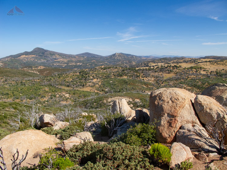
The view from East Mesa Fire Road
Brady and I got to the trailhead just after 6AM and were the only people there. The sun wasn’t fully up yet, but it wasn’t cold at all, so I was worried that it might get pretty hot as the day progressed. We headed out on the East Mesa Fire road and were almost immediately presented with a nice view of Oakzanita Peak, which would dominate the landscape for most of the day.

Looking back toward Oakzanita Peak from East Mesa Fire Road
We saw plenty of tracks in the road; deer, turkey and even some large mountain lion, but saw nothing other than lizards, squirrels, quail, and some rabbits.
While hiking up the road, we shared our varied hiking experiences and approached the area where we would start bushwhacking. I had scoped out the region from Google Earth, but I couldn’t tell which way was the best way.

This is where we left the trail and headed toward the bald spot on Sugg Peak, in the center
We encountered a clearing and started the off-trail portion of the hike, zig-zagging through the brush without getting too scratched. I should have worn pants. There are many trails noted on various maps of the area, but there wasn’t much to see once we got there. At least nothing that appeared to go in the right direction. I will have to come out again and explore different ways.
We then made it to a lovely grassy meadow that sloped downwards toward Pine Creek and we trudged through the knee-high grass to the base of Sugg Peak.

Headed across the grass to the narrow spot between the meadows
After trekking through more grass and navigating our way around a thicket of rose bushes, we arrived at the base of Sugg Peak. Everywhere we could, we hiked the exposed ledges of granite, minimizing our contact with the ever-thickening manzanitas, but it would be necessary to expose ourselves to the brush in order to make any progress.
Once near the peak itself, we encountered cairns here and there to lead us to the top, where we sat, admiring the incredible view of the Cuyamacas, Mount Laguna, and mountains into the distance. The weather was perfect and the view was so nice, it took an effort for us to be motivated enough to start our way back down.
The view from Sugg Peak, including Japacha, Cuyamaca Peak, Middle Peak, and Stonewall Peak. East Mesa is on the right

Survey Marker on Sugg Peak
We made our way back down and lost the cairns after a certain point, but roughly followed our same path back to the road. We were back to our car before noon. A great day of hiking.
Sugg Peak Overview Trail Map (Click to enlarge)
Sugg Peak Detail Trail Map (Click to enlarge)
UPDATE 04/15/2025
My daughter Sophia and I spent some considerable time cleaning up the trail from the northwest today. I had given it a good try 3 weeks before, able to summit, but came back with more tools and more help. I had also tried in 2021 and realized that the fires in 2003 likely made my first years peakbagging in San Diego easier than most years.
The slabs above the meadows area are fairly easy-going, but we trimmed a ton of brush and added some cairns here and there. It’s still a decent bushwhack that requires some navigation, but it’s worlds better than before.
There is now a use trail from East Mesa Road when there wasn’t one in 2010. I even saw some mountain bike tracks and wondered where they were going, since there aren’t any trails that go through around there.
There are some pink ribbons leading through the meadows and oaks to the base of the mountain, but then leads too far to the south (climber’s right), perhaps following what reads as Upper Ranch Track on some maps.
Generally, you go to the left of some trees at the base of the mountain, through the section with the least amount of thorn bushes and an open dirt patch, over a fallen tree through a trimmed tunnel of brush to the slabs.
Then generally stay climber’s right on the slabs until you encounter wading-height manzanita, where you start to angle climbers left. You emerge onto a mesa of granite and make your way to climber’s left down to cross a drainage. Follow the bottom of the drainage to the right for a bit, until you see a cairn and trimmed brush tunnel to the left and head up, following a few more slabs generally southeast.
Cross a trimmed wall of brush at the top of the slabs to the southeast to a flat sandy spot, then turn climber’s right and go up through trimmed brush and turn climber’s right for a bit. You’ll follow some open patches through the brush that turns to climber’s left towards a saddle above.
You’ll follow trimmed brush through a gap in an old barbed-wire fence and make your way to the saddle, resisting the urge to climb to the peak too early, going climbers right at a spot where you might start up through the manzanita.
At the saddle proper, there’s a flat rock in an open area. From the flat rock, you should see an easily-wading path through the manzanita to the top of Sugg Peak.
Reverse to the car.
Wear long pants and shirt; gaiters recommended. GPS helps. Be open to the bushwhack and enjoy being in an area that is relatively seldom visited.

