


Peaks #35-38 - Four Peaks and a Waterfall Near Julian
For those interested, here is a list of my gear that I have found works well for me. This is, of course, an affiliate link and your enjoyment of these may vary:
Oak Benchmark
Elevation: 3,965'
(Retired in 2022, replaced by Inaja Hill)
Peak 4159
Elevation: 4,159′
(DO NOT ATTEMPT, replaced by Red Butte)
Ant Benchmark
Elevation: 3,920′
(Retired in 2022, replaced by Peak 4292 in Kanaka Flat)
Peak 1546
Elevation: 1,546′
Mileage: 3.4 (4.5+ total to the falls and back)
Trailhead: Cedar Creek Falls Trailhead (East side, “The Saddle”)
Agency: Cleveland National Forest
Date Hiked: 05/08/2010
Peakbagger.com Page
Update 2018: Peak 4159 has been retired due to proximity to private property. Please do not attempt to hike to this peak. It has been replaced by Red Butte.
Update 2022: Oak Benchmark, which is often plagued by poison oak and is also a fairly short hike, was replaced by Inaja Hill.
Update 2022: Ant Benchmark, which is challenging to access without crossing private property, was replaced by Peak 4292 in Kanaka Flat.
For those interested, here is a list of my gear that I have found works well for me. This is, of course, an affiliate link and your enjoyment of these may vary:
05/08/2010
Once again, I set out to summit multiple peaks in a day. The hiking distance to each peak would be fairly short, but, over the span of the day, the mileage would add up.
This time, I had the PD with me, as we both are getting some hiking in to train for our upcoming Mount Whitney trip. The only limit to what we could do was the fact that we were to meet some friends at Cedar Creek Falls in between 12 and 1 PM. For most of the day, Cuyamaca Peak loomed over us on the horizon, beckoning us to its slopes.
We got an early start and enjoyed the drive through Ramona, saw a large doe cross the highway right in front of our car in Wynola, and drove to the first parking area. I hesitate to say trailhead, since most of the peaks we did today are rarely summited, so there was a lot of bushwhacking between the car and the summits. It was still cool and the sun had not risen over the far side of Oak Benchmark, our first destination.

The PD making his way up the side of Oak Benchmark
We shouldered our packs and got walking on the trail. We had to squeeze between two bushes, still moist with dew, to scout the base of the mountain for a good bushwhacking route up. About 10 steps after the bush, the PD noticed some ticks on his shirt. We both stopped and did a tick check. He had four ticks on him and I had three.
I was amazed. I have done a lot a hiking and backpacking over the years and I couldn't believe this was the first time I had seen a tick.
Actually, once before, summiting one of my favorite peaks in Joshua Tree, I saw one on my boot. But, other than that, I've had no personal experience with them. And we had seen 7 ticks in the first two minutes of hiking.

Still climbing straight up with flowers blooming
For the rest of the day, we gave each other "Tick Checks," and we ended up counting over 30 ticks between us. The good news is that only one of them had any skin contact, since we were wearing long-sleeves and pants for much of the bushwhacking. That tick was removed before it did any damage.
After seeing some quail and rabbits, and zig-zagging our way through thickets of manzanita, we easily made it to the top of the mountain. The Oak Benchmark highpoint is a little behind what appears to be the summit, but it is a few feet higher. We drank in the early morning views and bushwhacked a different way down back to the car.

Oak Benchmark - Cleveland National Forest

Cuyamaca and Middle Peak from Oak Benchmark
We drove to the next peak, which is unnamed and nearby. We parked off the highway again and hiked to the trailhead. The trail looks like it was an old ranch or fire road, but hasn't been used in a long time and the sign at the trailhead prohibits vehicular use.
This was a pleasant hike through a grassy meadow with purple flowers blooming as the trail meandered alongside the mountain. We reached a secondary summit, but could see the actual summit not far away behind a barbed-wire fence.
I had checked on several maps before I left that indicated that there was private property around here, but it was just north of the summit, not on the actual summit. So we hopped the fence and got to the summit.
It is a beautiful hike and a nice view from the top, but:
UPDATE 2018: Peak 4159 has private property concerns. Please do not attempt to hike this peak.

Trail to Peak 4159 (Do not attempt)

View north from Peak 4159 (Do not attempt)
We headed back down and went back to Boulder Creek Road. Any time we were near our car on Eagle Creek Road, we saw cars drive westward towards the Cedar Creek Falls Trailhead. I started to wonder how crowded it was going to be.
Update: Most cars going to Cedar Creek Falls now drive to the Ramona trailhead on the west side.
When I was out in this area hiking to Eagle Peak, I only saw one car on the dirt roads, and it did not appear to be a hiker.
We had to park pretty far from where I'd thought we'd start, since the "road" on the map, like the previous peak, hadn't been used for quite a while and Boulder Creek Road wasn't wide enough on which to park. Due to the heavy rains this season, there are serious ruts on either side of the road.

Meadow at the base of Ant Benchmark
Once on the old road, we hiked a while and then arrived at a beautiful meadow with flowers blooming at the foot of Ant Benchmark. We crossed the meadow and began another round of bushwhacking to the summit.
There were enough boulders on the mountain that made it easier. The view from Ant was pretty good. You could see as far as Viejas Mountain and El Cajon Mountain and the San Diego River Canyon, a 1,300' chasm in these mountains could be seen and felt from almost anywhere in the area.

The PD almost at Ant Benchmark
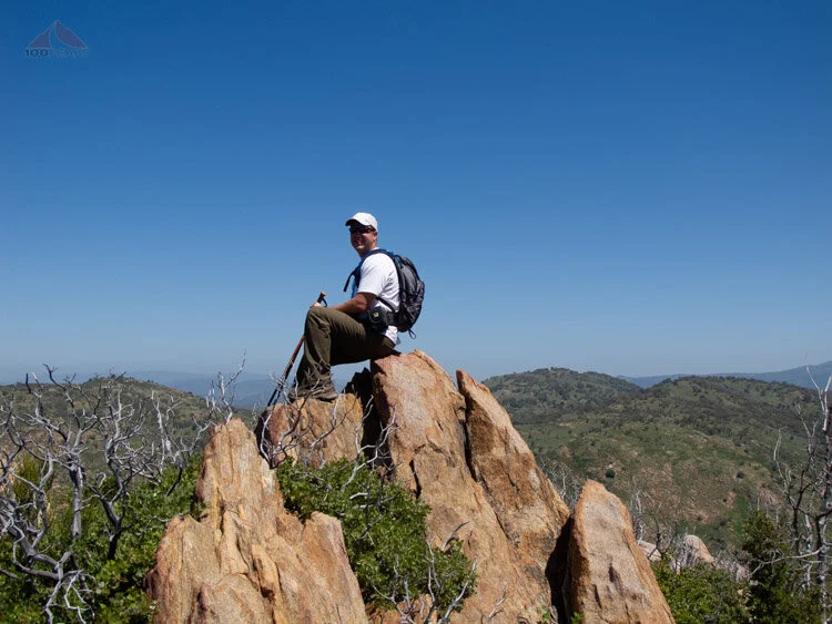
Me atop Ant Benchmark

Ant Benchmark

Another Ant Benchmark
We made it back to the car, happy to have made three peaks. I decided to start heading towards the Eagle Peak Trailhead and see if we could squeeze some more peaks in before we had to meet our friends at Cedar Creek Falls by traveling Cedar Creek Road, which appeared on the map as pretty rugged.

The PD descending Ant Benchmark with Cuyamaca Peak in the background
By the time we got to the area, it was getting late, so we went directly on Cedar Creek Road and enjoyed some bumpy dirt road driving and got a great view of Sunshine Mountain, another peak that looks like great fun and is on my list for the future. We saw a snake in one of the ruts in the road, sunning itself. It didn't move, so we drove around it. It didn't appear to be a rattlesnake.
We got to the Cedar Creek Falls trailhead, known as the Saddle on the Topo maps. There were 20-30 cars there. I have never seen so many people at a trailhead before. Looks like the word was out. The heavy rains this year made the falls spectacular and the warm weekend drew visitors by the carload.
The danger with this hike is that inexperienced hikers start this hike in the cool of the morning with little water ("We're going to a waterfall!") and hike downhill towards the falls.
Maybe they'll be carrying a bottle of Evian in one hand. They end up swimming and jumping from the cliffs and some even start drinking beer at the falls. They then start the hike back and the temperature is 30 degrees F warmer than before and they need to gain a total of 1,000' feet of elevation in about 2+ miles. And they may have drunk all of their water below, if they brought any at all.
We hiked down and enjoyed the views of the San Diego River Canyon, Mildred Falls to the north, and could see the relatively new West Side Trail plunging down into the canyon. We encountered some people debating at a fork in the trail, wondering where to go.
I shook my head. Shouldn't they have all studied the maps and made this decision before they even decided to go on the hike?

Mildred Falls from the Cedar Creek Falls Trail
We took the left trail spur that leads to the top of the falls.
On the way, I could see a trail leading straight up the side of a small mountain, noted on my map as Peak 1546. I could imagine that the view of the canyon to the west would be great from the top, so we decided to add on another peak to the list.
After a short, but extremely steep, hike to the top of Peak 1546, we weren't disappointed. With Eagle Peak looking above us to the southeast, we could see down the canyon to El Cajon Mountain so the southwest.

San Diego River Canyon and El Cajon Mountain from Peak 1546
Four peaks in a day was a good number so we began our descent to the falls and got to the rim. This was the highest number of bathing suits I have ever seen on a hike.
While I attempt to not be a hiking snob, it was hard to contain my amazement at the lack of preparation and haphazard way people were handling themselves. A hatless, shirtless guy carrying an almost empty water bottle in one hand was scrambling down a dangerous section of the trail, with only one hand to aid his descent. People with dogs were going up and down some pretty steep scrambling areas, too. I hope the dogs had enough water. (Hint: many dogs have died on this trail.)

The PD at the top of Cedar Creek Falls

The crowd at the bottom of Cedar Creek Falls

Cedar Creek Falls
We stayed a little bit and visited with our friends, but, to be honest, I was ready to go. I go hiking for relative solitude and quiet. I was happy to have seen the falls, but would only return on a non-holiday weekday.
We hiked up and out of the canyon and when we neared 9 miles for the day, I started to get tired. I realized that should have eaten a little bit more and noticed the strap on my pack was limiting the flow of water. I corrected this and we made it back uphill to the trailhead and the car.

Stream crossing on the trail back from Cedar Creek Falls
On the way up, we saw an already reddening guy wearing no shirt and no sunscreen carrying nothing except a case of beer downward towards the falls. I shook my head again.
Sorry for the rants, and I understand that if you are reading this blog, you likely already know this:
Hiking is an inherently dangerous activity. Don't make your leisure activity anyone else's responsibility by failing to be prepared. Even I make mistakes, and I consider myself fairly meticulous. Being completely blasé about hiking can lead to unpleasantness, a rescue situation, or death.
Be careful out there, people.
All that being said, it was a great day of hiking after a very wet winter and spring, and I am really enjoying this part of San Diego County. Much of it is rarely hiked, but there is so much to see.
Since this post was written in 2010, a permitting system has been put in place by the Cleveland National Forest for Cedar Creek Falls.
