


Piedras Grandes and Indian Hill - Peaks #32 and #33 - A Loss of a loved one

Dos Cabezas Water Tower
Piedras Grandes
Elevation: 2,601′
Miles: ~2
Trailhead: Dos Cabezas Water Tower (Could be challenging to cross the tracks)
Date Hiked: 03/14/2010
Peakbagger.com Page
Indian Hill
Elevation: 2,240′
Miles: ~2
Trailhead: Dos Cabezas Road
Date Hiked: 03/14/2010
Peakbagger.com Page
Agency: Anza-Borrego Desert State Park
For those interested, here is a list of my gear that I have found works well for me. This is, of course, an affiliate link and your enjoyment of these may vary:
On this Sunday morning, I scrambled atop a small rise and saw a large coyote turn and look at me, then run down the rise into the desert floor below, joining other coyotes to disappear among the cactus and chaparral.
The morning was beautiful, the sun was shining on my back and the breeze had enough chill in it to cool me from my exertion. Other than the birds, it was completely silent and I was the only person for miles. I was completely filled with the joy to be alive at that moment. I took a breath and continued up the mountain.
I found out later, that at roughly the same time, someone dear to me had passed away. It was sudden, and it wasn’t supposed to be her time to go. She was too young and too healthy. Random. Shocking.
Over the last few days, I have moved from denial to grief and acceptance. She was my favorite aunt. She gave me my first cassette tape, U2’s Unforgettable Fire, when I was 12. I was initially disappointed, since I didn’t know any songs on it. But it quickly became one of my favorite albums of all time. I learned every word and nuance on the album. Over the years, I felt like she always understood me. Her sons, my cousins, became my good friends throughout my childhood years.
She wasn’t my aunt by blood, but that didn’t matter to me, or to anyone in my family. She could always be counted on. Since my childhood, we grew apart, as people do, I moved away and I saw less of my cousins and my aunt. I still enjoyed her company on holidays and always knew she was there.
My wife had to break the news to me and I’ve made it very clear over the years that this aunt was very special to me. She took care of all of those around her, from her mother to her grandchildren.
As my emotions run all over, I’d like to think that the coyote I saw on Sunday was a message sent from the spirit world saying a last goodbye before she rejoined other spirits in the great desert basin of the sky.
---
It’s been a couple of days and I am now writing the trip report, which lost all significance in light of Sunday’s passing. However, life is about living it, so on with the trip report.
I initially had grand aspiration of conquering 5 peaks in one day, but several things got in the way of that:
Dirt roads to desert trailheads are slow to drive on
Easy to make wrong turns on said dirt roads
Cacti make bushwhacking more difficult
Some rock scrambling may be necessary
Routes up to peaks may be hard to find and require multiple attempts
I had forgotten about daylight savings, in which I lost an hour of sleep
On top of all of these things, my printed topo map fell out of my pocket on the way up to Indian Hill, so I stayed on the trail for most of the way. I had a topo map on my iPhone via AccuTerra and AllSport GPS (though cell coverage was spotty for the latter), but I have a rule: No paper, no hiking, unless it is a well-established trail. This was hard cross-country hiking, so I took it as a sign to not take any chances.
I left my house when it was still dark, but the sun was warm and shining by the time I got to Dos Cabezas in Anza-Borrego Desert State Park. I saw the water tower with homage to Tool’s 10,000 Days album artwork that a fan had scrawled on the side. While I am also a fan, I was put off by someone’s compulsion to deface a historical relic in a State Park. I drove a little bit further to a small wash and started my way up to Piedras Grandes.

Green Desert

Flowers among the cacti
Like I stated above, it was a beautiful morning. I saw a lot of rabbits hopping around and the birds were everywhere. It felt good to be back on the trail. Noting the time I left the trailhead, and I use that term loosely, I figured I wouldn’t be summiting all the peaks I wanted to today. The desert was abnormally green, with little flowers starting to poke out there and there, but not that explosion that will happen in a week or so.
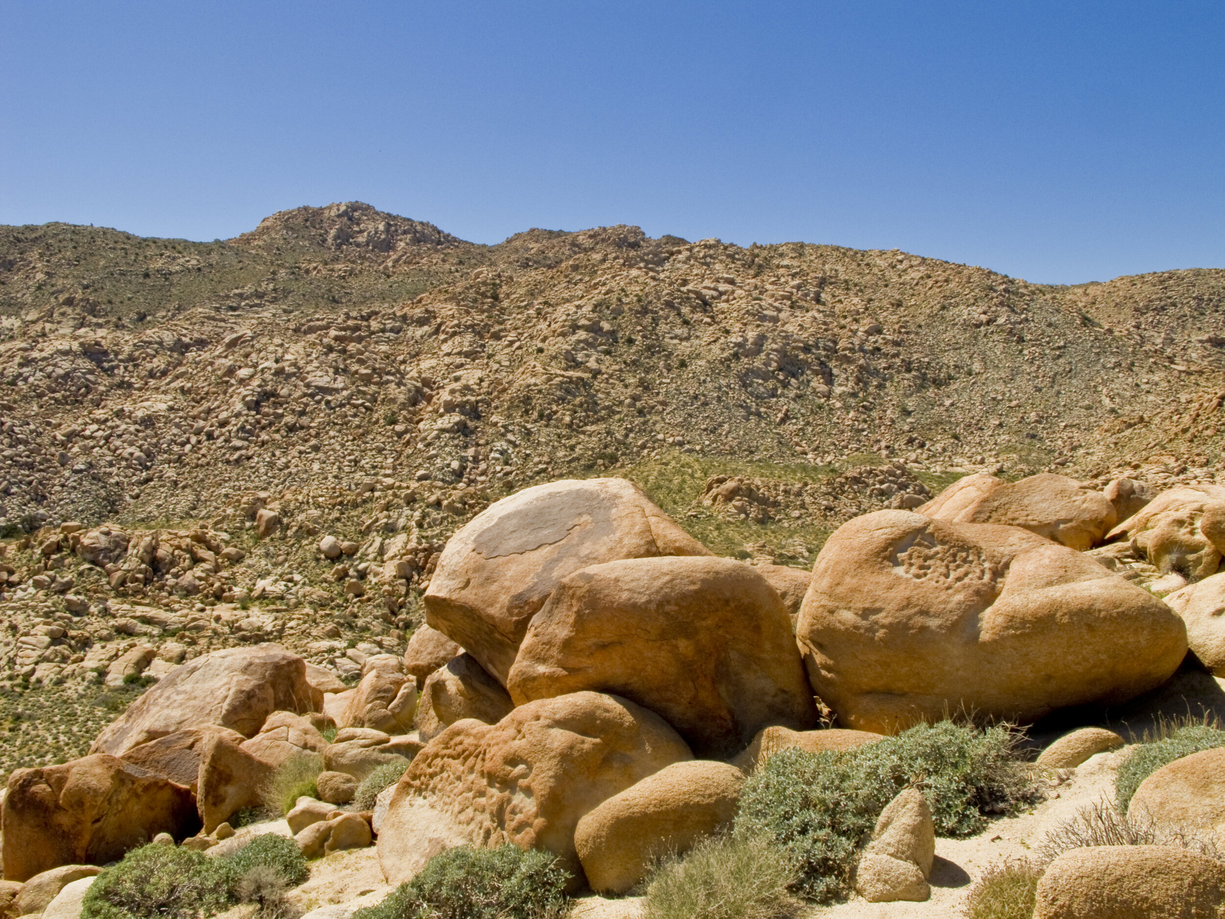
Although the way to the peak looked pretty rocky, I was able to make it to the top without using my hands to scramble. Minimizing the scramble factor is a goal of mine on these peaks. The view was great and I could see all the way down to Dos Cabezas with Red Hill, Mine Peak, and Carrizo Mountain beyond it.

View of Dos Cabezas with Carrizo Mountain in the Distance From Piedras Grandes
I made my way back down to the car, feeling great and headed down the dirt road towards the area near Indian Hill. By this time, I had removed one peak from my possible summits for the day and was ready for three more. I immediately made the wrong turn and ended up in a wash filled with deep sand. Luckily, the all-wheel-drive Tiguan handled it without a problem, only getting a little loose in a couple of sections. I turned around and drove a bit and got my bearings and headed northeast. I soon came behind some trucks attempting to navigate a steep hill. They ended up pulling over and parking, hiking from there.
I got out of my car and jogged up the hill to take a look. The pits in the road were just too deep. My AWD would have handled it fine, but I had clearance concerns. While standing on top of the hill, I saw another road come from another direction and meet this road without having to scale the hill, so I got back into my car and retraced my path for a while and found the road and passed the hikers on my way down the road.
Everywhere I’ve read has explicitly stated that hiking on the railroad tracks in this area is illegal, yet I saw several groups of people park and immediately use the tracks as a trail. Perhaps they don’t realize that the tracks are still in use on a daily basis and that it’s dangerous behavior, particularly in the narrow sections and through the tunnels.
I parked and starting hiking down an old 4x4 trail that is no longer in use, although I did see some tire tracks on it. I don’t know how they got there. And it was only for part of the way. I cut across the desert to scale Indian Hill. From the top of Indian Hill, I could see the next peaks on my schedule and the route immediately ahead of me looked daunting. I decided to follow the mountain range a bit to see if I could find a good way up.
Looking towards Moan Benchmark from Indian Hill
As I went in and out of small washes and canyons, I noticed the day was getting late. I had already scaled two peaks and had a long way to hike back and drive home. I decided that the rest of the day would be to do recon for next time.
I hiked the jeep trail all the way to the railroad tracks and tunnel. I saw a chubby horned lizard scamper across the trail and sit still, so I took some photos of it. This one was a different color than the ones I saw on Mount Gower or Combs Peak.
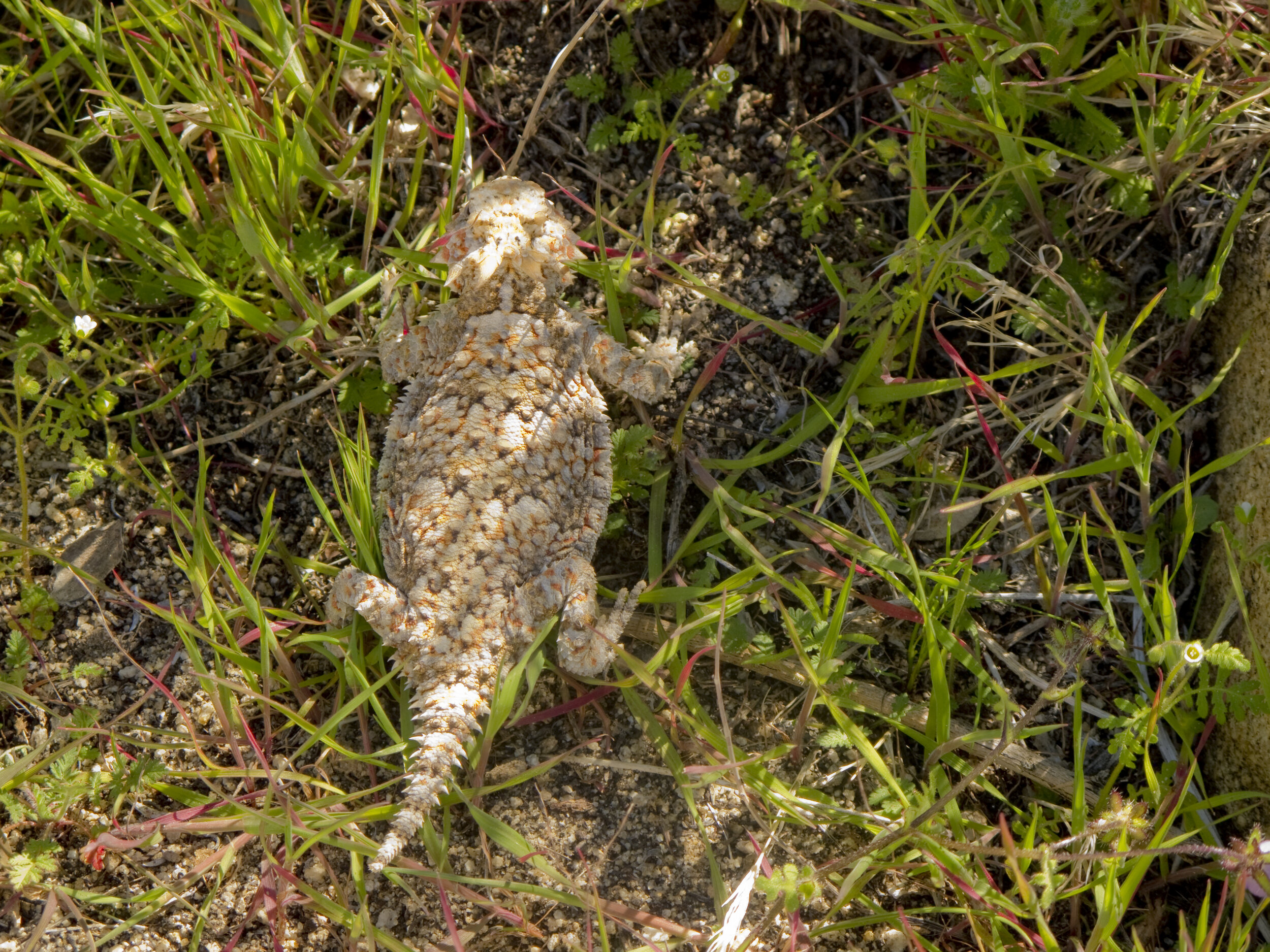
Horned Lizard near Carrizo Canyon
Near the railroad tracks, ON THE TRAIL, someone had decided they had waited long enough and did their business right there and left the toilet paper and everything. Is common decency not that common? Maybe they had the impression they were the only people that would ever see this “secret” place that is in several popular guidebooks.

Train Tunnel near Carrizo Canyon
I jogged an easy 2 miles back to the car and headed out, driving seemingly forever on dirt roads. For the record, Mortero Canyon Road seemed a lot shorter and easier to navigate than Dos Cabeza Road.
It took me about 3 hours to get home to some bad news. But, overall, after about 6-7 miles of desert hiking, it was a great day to be outside.
